
This exhibition showcases 45 magnificent maps, books and illustrations from the Quivira Collection. The maps and illustrations in the Quivira Collection date from 1540 to 1802, a span of 260 years or so. These dates also bracket a period of history unprecedented for the general expansion of knowledge and information. The first application of the new technology of printing to maps and geographical knowledge coincides almost exactly with Columbus’s first voyage in 1492. Thus the maps in this collection span the transition from the European Renaissance to the Age of Enlightenment and bear eloquent testimony to the expansion of useful knowledge. The collection portrays the following significant exploratory events:
- Fact and Fantasy, the Earliest Explorers and the Legend of Quivira (mid 1500′s to mid 1700′s)
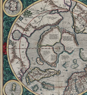
- California as an Island (mid 1600’s to late 1700’s)
- Secret Russian Explorations in the Pacific (1752 – 1775)
- Captain James Cook’s Voyages to the North Pacific (late 1700’s)
- In The Wake of Captain James Cook (late 1700’s)
- Overland to the Pacific (late 1700’s)
The mapmakers and their origins, including Germany, Italy, Northern Europe, and England, provide a sampling of the history of cartography in Europe from the mid 1600′s to the late 1800′s. Collectively, the maps constitute a significant representation of European knowledge of the northwest coast of America at their respective times. Some are quite rare, and all are works of art as much as compendiums of knowledge.